Sunday, July 13, 2014

Fort Whyte Alive / Carolyn Sifton Trail

Fort Whyte is one of those little gems within the city that some people and families take full advantage of, but many others rarely visit. Like most 'Peggers, I know about Fort Whyte Alive but rarely have I ever gone there and I'm not really sure what they have to offer.

After my run yesterday I still don't really know much about it, but I'm sure I will be going back.

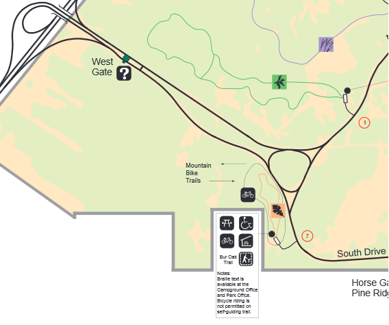
For some reason the Winnipeg Trails website doesn't have a proper map of the trail through Fort Whyte, but there is this map:


.. and there are better maps on the Fort Whyte website.

DESCRIPTION:
I parked at the reception centre, which might have been a bit of a mistake. Firstly, there is a sign saying that you need to report to reception and pay $7. I wasn't clear if you needed to pay just to jog on the trail, especially since it's easily accessible from other city trails, but if you don't pay the sign will make you feel guilty. Secondly, it's difficult to find the south leg of the trail from there because there is a maze of boardwalks and paths to navigate. If I were to do it again I would park south of McGillivray and start at the south trail head.

Anyhow, I only ended up running the longer north leg of the path, which includes a scenic loop called the Carolyn Sifton trail. From that loop the path winds northward until it hits the paved trail along Stirling Lyon Parkway. The total trail length is probably about 5 km, but the part I did was about 3.5 or 7 km return.

The trail is crushed limestone and in good condition. It also weaves and winds quite a bit, even in the open areas, making it less dull than many other city trails.

REVIEW:
It can be busy. You will encounter a variety of cyclists and walkers in groups and on their own, moving at different speeds. It didn't cause any problems for me, but just be aware of others.

The trail is very flat, with the exception of the occasional mound which you can run or walk up to view the surrounding area. Part of if passes by the bison enclosure where you can see the buffalo ... not roam exactly, but ... exist. Still kind of cool.

There is also network of boardwalks and other paths that might not be suitable for running on, but might make a nice walk for cooling down

You will also see small lakes, trees and flowers, and wild grasses. It is nice, but it feels a little awkward running and sweating down a trail where families and tourists are sightseeing.

SCORE: 6/10

GOOD STUFF:
  • decent length and condition
  • stuff to see
  • not straight and boring
  • connects to other city trails
BAD STUFF:
  • lots of people
  • flat
  • might cost you $7
My results. (I wasn't in a running groove this day):


Sunday, July 6, 2014

Bur Oak Trail (Mountain Biking)

I didn't run on any interesting new trails this week, but I returned to one of my favourite biking trails: the Bur Oak tail in Bird's Hill Park.

Bur Oak is actually three trails in one: a paved walking path, a short off-road bike trail, and a longer and more technical biking trail. Please do not walk on the bike trail. You may snow shoe in the winter, but if you walk on it in the summer you will be run over.

DESCRIPTION/REVIEW
The bike trail was planned and built by a local bike club -- I don't recall which one, but they did a good job. There is a wide variety of terrain and it makes for an interesting ride, especially if you venture off into the more technical loops.

You will find long, flat straightaways, twisty turny sections with exposed tree roots and rocks, sandy areas, muddy areas (depending on the weather) and some really fun roller-coaster stuff.

You can get a hint of the variety in the terrain from my Garmin stats, if you look at the speed graph. There are some areas where I was zipping along at almost 30 km/h and some where I was grinding at less than 10:


Even though there is only 13 m of elevation change on the course you are going up and down quite a bit in some areas. It's not a super technical ride, but wear your helmet. You could clip a tree with your handle bar or catch a rock the wrong way and go for a tumble.

It's a nice length too. At 6.8 km (4 miles) it's not long, but gives you a good half hour ride. If that's not enough, do the same loop in reverse direction for a good hour long work out -- depending on how fast you ride. If you're a little tired, take one of the short-cuts to bypass the technical areas and shorten the loop.

After you're done, grab a drink from the cooler in your car and walk the paved trail to cool down, or drive to the nearby beach.

It's the best off-road biking trail in the vicinity of Winnipeg in my opinion

SCORE: 9/10

GOOD STUFF:
  • great variety of terrain
  • good length for a morning or afternoon spin
  • possible wildlife sightings
  • beach nearby to cool off and walking trail right there for a relaxing stroll after the ride
BAD STUFF:
  • need a park pass
  • more elevation change would be nice
I don't have any photos from today, but I will post again about this trail. Meanwhile here is a photo from last fall:


Saturday, June 14, 2014

St.Norbert Heritage Trails / Cloutier Trail

Last time I went to the eastern fringes of Winnipeg to explore a trail in Transcona. Today I traveled to the southern point of the city to explore the St. Norbert Heritage Trails. Like Transcona, St. Norbert is sort of its own distinct community within the city limits, although very different in almost every other way.

St. Norbert Heritage Trails is an umbrella term for actual trails and designated streets through St. Norbert. The actual trail that I started on is Sentier Cloutier Trail, which translates into "Trail Cloutier Trail". For simplicity, I shall refer to it as "Cloutier Trail" in this post.

St. Norbert Heritage Trails


DESCRIPTION
Cloutier Trail is a short paved trail that starts at the very south-eastern point of Fort Richmond next to the Red River, ducks underneath the very noisy Perimeter Highway, passes through a small but pleasant forested area and follows Cloutier Drive up to Pembina Highway.


REVIEW
At only 2 km in length it's really not much of a trail, but the area along Cloutier Drive is park-like and the trail has some small curves in it making it at least a little bit interesting. It also serves as a useful link between the city north of the Perimeter and St. Norbert. When I reached the end of the Cloutier trail I continued down the sidewalk, dodging people walking to and from the farmer's market, and made my way into the streets of East St Norbert.

I knew that somewhere there was a park with another small trail that I would try out, but I couldn't remember how to get there, so I followed the signs. They have these trail signs posted to lamp posts on otherwise very ordinary residential streets.


I jogged along looking for these signs, but before I was able to find anything resembling a trail head I had ran almost 5k and it was time for me to turn around. Although the streets in St Norbert are quiet and generally pleasant to look at, a street is not a trail.

SCORE: 5/10

GOOD STUFF
  • Nice greenery along the trail. Some treed areas, some grassy areas.
  • Spiffy houses on the south side of Cloutier Drive to look at.
  • Takes you to St. Norbert, a very nice area of town. A person could easily park in Fort Richmond and walk to the farmer's market on a Saturday, although that would limit the number of jars of jam you would want to buy.
BAD STUFF
  • Short
  • Highway noise
  • Poor connectivity to other trails
I don't recommend this one for joggers, but it's a nice little trail for casual walkers. It would be great if they could build additional trails along the Red River, connected to the Cloutier Trail, to make better use of that space. From Google Maps it looks like most of the river bank is undeveloped.

My results are posted below. I had a cramp around 6k that forced me to walk for a while. That hurt my average pace, but still a pretty good run.


Thursday, June 5, 2014

Transcona Trail & Bioreserve

I normally try (really hard) to avoid Transcona. It's not that anything bad ever happened to me there. It's just that dislike driving in and around Transcona and I have a possibly unwarranted negative perception of Transconites as unsophisticated Camaro-driving mullet-wearing bumpkins that just don't fit in with the rest of the city.

Despite these prejudices, I chose a trail in Transcona for my inaugural post in this new blog of mine. As I train up for a half marathon in the fall, I hope to try out many of the city's trails and paths. For whatever reason I chose this one tonight.


DESCRIPTION
Paved and 6.7 km in length, although I only ran a portion of that. It is very straight and follows a rail line and power lines for much of it's length, but it is also treed and has relatively few road crossings, which is important. The busiest crossing at Plessis has crosswalk buttons to stop traffic.

REVIEW
I parked at one of Winnipeg's rare off-leash dog parks, near where the trail crosses Plessis. I think there was a drug deal going on when I pull up. There are two things in this park: a play structure for kids and a open space for dogs, and the teenagers in their urban wear had neither, but they buggered off after I parked and I got on with my run.

The trail is well used by couples going for a walk, cyclists, dog walkers and rollerbladers, all in vast assortment of sizes and apparel. It's not a bad place to go for a little people watching as you jog.

1.3 km down the trail from where I parked, I diverted off the path, across the rail tracks, and around the Transcona Community Bioreserve -- a naturalized old industrial site that made the news a little while ago when local residents fought against a planned concrete plant near by.

The trail through the bioreserve is crushed limestone, and follows a loop around a swamp. It's quite pleasant, with a soundtrack of frogs and birds, mixed in with the traffic from the Perimeter Highway to the north. I definitely recommend it, unless it's after dark.

Overall score: 6/10.
Highlights: Good condition, easy parking, connections to other parks and short trails including the Bioreserve and the Cordite Trail. Also, the possibility of a rare caboose sighting as the Central Manitoba Railway train passes by.


Lowlights: Straight, marginal scenery, in Transcona.

At the end of the day, when I got in my car and followed a Camaro (true story) out of Transcona and into the setting sun over Winnipeg, I left pretty good about my evening. The excellent weather certainly had something to do about it, but the trail and Bioreserve are certainly worth exploring if you're a runner or walker and don't like too far away.